
Preserve before demolition
Paris and Brussels represented in the photographs of Charles Marville and Ghémar FrèresExtract
Charles Marville’s 425 photographs of Parisian streets and Ghémar Frères’ photographs of the banks of the Senne in Brussels are well known for their beauty, and are often associated with melancholy, or, on the contrary, with the recording of bad housing conditions. Both series were ordered by the cities between 1865 and 1867; both cities would destroy the subject of the photographs – the buildings – immediately thereafter. The question of the original purpose of the photographs has never been asked. A close reading of relevant documents makes clear that Marville’s photographs were meant to serve as tools for mapping medieval streets in the Topographie Historique. Probably influenced by Marville’s project, and with a remarkably similar relation to mapping and topography, Ghémar’s views of Brussels should be understood in the same context: as a contribution to the visual archive of the city itself.
Capturing transformations
They were both former painters who ended up making beautiful photographs. Since the 1970s their photographs have been reproduced and discussed in the contexts of ‘intention’, ‘composition’, ‘perspective’, and ‘oeuvre’. Ghémar Frères and Charles Marville have entered the history of photography in the same discourse as, for example, Man Ray.[1] Without wanting to deny the aesthetic qualities of most of the images that bear the names of the first two, there is one important difference that sometimes seems to be overlooked: Man Ray was a twentieth-century modern artist who made photographs as part of his artistic expression; Ghémar Frères and Charles Marville were nineteenth-century commercial photographers whose first aim it was to make money by selling photographs, receiving orders from large institutions.[2] In the following cases, these institutions – the Cities of Brussels and Paris – used the medium of photography in the 1860s to record traces of their own physiognomy that they were about to destroy. These traces were preserved in the albums known as the Album du Vieux Paris and Assainissement de la Senne. In the history of photography these albums are praised for their ‘melancholic beauty’ and ‘poetic memories’ or their ability to show the bad housing conditions: the modernist ideal of the photographer as artist making artworks out of artistic or political vocation has supplanted the question why the cities ordered these photographs.
In both Paris and Brussels, there were more photographers who captured the transformations.[3] However, the cases of Marville and Ghémar are unique because of their direct relation to their city administration and because of the nature of their photographs.[4] In Paris, the Ville de Paris did not hire any other photographer to document the streets that would be demolished; in Brussels Ghémar was the only photographer to work for the Belgian Public Works Company and to publish photographs of the disappearing Senne banks.
What were the photographs supposed to capture in these bad, ‘dying’ parts of these capitals – capitals that did everything to appear modern? Why did they choose for photography? Was there, at that point, any melancholy involved? And were the two orders, so similar and simultaneous, related? In the following, those questions will be answered. The original orders seem to be lost. By looking at the discourse that was related to the photographs and the context in which the photographs were used initially – without forgetting to look at the photographs themselves – new perspectives on the famous views can be found.
Seine: Haussmann’s man
The 425 photographs Charles Marville made of the seemingly empty medieval streets, eternalized shortly before Haussmann would have erased them, are known as the Album du Vieux Paris (figs 1 and 2).[5] The name is confusing: there is no album, there are only two ‘complete’ series of albumen prints of 29 x 38 cm: one in the Musée Carnavalet, and one in the Bibliothèque de l’Hôtel de Ville, both in Paris.[6]
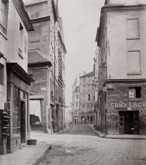 |
Fig. 1. Charles Marville, Rue des Grans-Degrés, Paris, 1865-69. Albumen print, 304 x 266 mm. Courtesy Charles Isaacs Gallery and Howard Greenberg Gallery, New York |
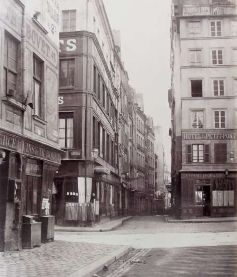 |
Fig. 2. Charles Marville, Carrefour des rues de la Bûcherie du Petit Pont et de la Huchette, Paris, 1865-69. Albumen print, 312 x 268 mm. Courtesy Charles Isaacs Gallery and Howard Greenberg Gallery, New York |
When, in 1964, Beaumont Newhall baptized Marville as one of the first documentary photographers, he saw personal engagement in the photographs. ‘It is not enough to set up the camera and record unthinkingly that which lies before it; choice of stance, choice of time of day, choice of details to emphasize or to subdue are subjective matters.’[7]
Around the 1980s, several exhibitions were organized around the photographer and around the technically very well executed images of Paris before, during and after the transformation works led by Georges Haussmann, Prefect de la Seine, (‘mayor’ of Paris) from 1853 until 1870.[8] The perspective on the photographs changed. Whereas Newhall had found ‘the melancholy beauty of the past’ in the empty streets, Maria Morris Hambourg called Marville ‘Haussmann’s man’: he ‘showed the dirt and darkness of these damned streets, quite in sympathy with the rigorous, relentless logic of the Prefect’s plan’.[9] This is a remarkable point of view. If Haussmann really needed views of these ‘open sewers’ only to prove their insalubrity, he would never have ordered and paid for over 400 photographs.
There is very little information on both the person behind Charles Marville, or is about the Haussmann administration. The fire in the Hôtel de Ville during the Commune in 1871 destroyed most traces, including, probably, Marville’s initial order of 1865, the year of which we know he started to make his photographs.[10] Marie de Thézy initiated several publications on the photographer in the 1980s and ’90s.[11] She stated that Marville had received an order from the City in 1865 to make photographs to capture ‘old ruined roads […] to preserve the souvenirs of the past’ – a statement that has often been repeated.[12] The detail that was neglected is that this statement is based on letters written eight years after the photographs were made, years during which not only the city archive, but also Haussmann, his emperor Napoléon III, and the streets had vanished. The circumstances had changed drastically.
Indeed, in a letter of 20 February 1873,[13] the words on preservation of the past can be read.[14] ‘Before starting the big breakthroughs that have changed the character and topography of Old Paris, the administration thought it would be interesting to preserve the souvenirs of the past, and it was in this line of thought that it ordered Mr. Marville to make a series of 425 views on destroyed streets, or streets that were about to be destroyed.’ It is a letter written by an administrator of the Service du Plan to its superior, the Directeur des Travaux de la Ville de Paris.[15] It is not a copy of the original order of 1865, and it was not sent to Marville; it is an internal note. In the draft of the letter can be read that, before sending it to the Directeur, it went to the Service des Beaux-Arts.[16] Based on this letter, the only statement that can be made is that in 1873, Parisian civil servants agreed on the relevance of photographs made by Marville showing streets before Haussmann had destroyed them, that had been made for the City of Paris some years before. They were interested for two reasons: the photographs could fill the void in the archives caused by the fire in the Hôtel de Ville and they could be of use for the publication called Topographie Historique.
Instead of what De Thézy suggested, it had been Marville who had initiated the correspondence. On 30 January 1873, the photographer had written to the director of the Service des Travaux de Paris to remind him that he still had the negatives of the street photographs at home, while earlier prints of the photographs executed for the ‘Administration Municipale’ had vanished at the fire.[17] In that letter the photographer confirms that he made these pictures for the Ville de Paris.[18] Marville was a businessman, and since he still owned the negatives, he could profit from the situation by selling the prints again. He calls the pictures ‘vues des voies’ – not a reference that suggests empathy with the poor inhabitants who had to move. By mentioning ‘Topographie de Paris’ instead of ‘Histoire’ or ‘Topographie Historique’ as field of interest of the pictures, and by addressing himself to the ‘Directeur des Travaux de Paris’ – the chief of all services concerned – instead of to the ‘Travaux Historiques’, we can conclude that there was no explicit relation between Marville and the Travaux Historiques. Also, assuming that a photographer who works in commission does not change the description of the work while communicating with his commissioners, it appears that the photographs Marville made of the ‘old streets’ of Paris were not made as melancholic souvenirs, but as ‘views of streets’, as documents that could serve the City administration in their ambition to complete their archives. The original order for the photographer was not to show how dirty the streets were, or how narrow – it was not a way for Haussmann to legitimate his destructions, as has been suggested – at least not overtly.[19] To find out what purpose the ‘vues des voies détruites ou à détruire’ were supposed to have in Haussmann’s administration, a closer look at the publications of the 1860s is needed.[20]
Seine: Le Vieux Paris
As the civil servant acknowledged in the letter of 20 February, the pictures could be of great interest when new maps of the old and new city were needed. Trying to convince his superior, he formulates his statement in the past tense, but with a message that can only be written after the transformation.[21] In this mixture of tenses, he calls the transformation works ‘activities that have altered the character and topography of Old Paris, “le Vieux Paris”’. A name written with a capital V, it refers to a well-known concept at the time, not only to a description. As Guillaume Le Gall has demonstrated, ‘Le Vieux Paris’ has its origin in the 1830s, when writers like Honoré de Balzac and Victor Hugo evoked a return to the Paris of their youth.[22] From the 1860s on, when Haussmann’s transformation started, the activities provoked melancholic publications from Haussmann’s adversaries, on a Paris that disappeared forever, once again called ‘le Vieux Paris’. These were publications with neither illustrations nor photographs; this city only existed in the descriptions and in the memory of the people. At the same time, Haussmann himself used this same notion of ‘Le Vieux Paris’ to turn down the protests against his expensive transformation work, and presented his Vieux Paris as a ‘cité antédilluvien’, before poverty and decay had taken control of the capital. Recent nineteenth-entury history or housing conditions were irrelevant in this context. It was this innocent city that the administration wanted to be preserved in museums and archives. It was also this city that should be displayed in the Topographie historique du Vieux Paris.
The Topographie Historique, the publication the employee of the Service du Plan refers to as a possible purpose for the photographs of Marville, was edited by Adolphe Berty.[23] In the first edition of 1866 – thus probably when Marville had just made his first series of photographs – Berty explains the purpose of the series. As an historian dependent on the writings of other historians, for a good understanding of their writings one wants to imagine where these early historians lived, preferably with accurate maps. But the historians that made the archives that Berty wanted to base his reconstruction on were often inaccurate.[24]
He developed a method that he proposes to use in the entire Topographie Historique: he wants to trace the course of the outside walls of the buildings, lines that barely changed in the course of the centuries.[25] Houses were mostly rebuilt on the foundations of older ones, Berty argues, so the outer walls almost never change their course. When this information is provided, historical plans can be reconstructed. By ‘remonter l’échelle des temps’ and many other methods that Berty does not want his readers to bother about, Berty tried to acquire information about the history of the city.
Was it photography that Berty was hesitant to mention? ‘We don’t pretend infallibility; but what we can say, is that our reconstructions, of which the exactitude has been often confirmed, were made with a probability that is completely scientific.’[26] Photography was considered one of the most objective and accurate measurement techniques.[27] The photographs that Marville made do fit perfectly in the mysterious description: the emphasis on the walls, the street corners that are in almost every picture to make sure the street will be recognised, and the disregard of details such as shop windows or contemporary elements. The walls were supposed to provide the data the historians failed to give in their descriptions. Neither the street with its houses that Haussmann would destroy, nor the contemporary inhabitants were of importance. It was the pattern of the walls, emptied of human activity, which was the main focus of the administration. Marville’s photographs had been ordered by Berty to serve this ‘highly accurate’ method.
Berty focuses on the time before Louis XIII.[28] He states that the readers might be disappointed that no bird’s-eye view is added to the Topographie Historique, but ‘nothing is more difficult when one wants to maintain precision’.[29] Since Berty’s method only provided information about the location of the outer walls but not about the structures above, it would be impossible, in Berty’s eyes, to provide a ‘realistic’ view of the houses. It is in this, the statement of the historian who worked on the Topographie Historique during the time that Marville made his photographs, that we can understand what Marville’s photographs were intended for: that was not to show what ‘the streets’ looked like in former years, or to legitimate Haussmann’s destructions. The images were in the first place instruments that served the reconstruction in maps of the street pattern before the death of Henri IV in 1610.[30]
The first volume of the Topographie Historique comprises the region of the Louvre and the Tuileries, and consists of 412 pages, with only a few illustrations, mostly maps of buildings or housing blocks, where every individual house is indicated.[31] It is in the publication of these maps that Marville’s photographs seem to have been of use for the first time.
The other editions of the series touch on the neighbourhoods Marville photographed (and Haussmann destroyed). It would be only in 1887, long after both Berty’s and Marville’s death, that a few photographs would be used as illustration, in the fifth edition of the Topographie Historique.[32] And only there, a first subtle trace of melancholy can be detected.
Senne: Sanitation and Suys
‘As a paradox, this documentary photography is not impersonal at all. There is no question of mechanically recording a random place that is in front of the camera: time and day of every specific ‘view’ need to be chosen carefully’.[33] In almost exactly the same words as Newhall in 1964 had done with Marville’s photographs, Gustave Abeels in his 1977 book on early photography in Brussels describes the series of photographs Ghémar Frères made in Brussels of the disappearing neighbourhood around the river Senne. As the title page of the album indicates, the Belgian Public Works Company Limited had commissioned Ghémar: ‘Assainissement de la Senne. Bruxelles en 1867. Vues photographiques prises à l’emplacement du nouveau boulevard à ouvrir au travers de la Ville de Bruxelles, par Ghémar Frères. Pour la Belgian Public Works Company.’ Abeels states, ‘this company commissioned Ghémar to photograph the picturesque corners along the old Senne that were supposed to be destroyed’.[34] Unfortunately, no reference is given for this statement. In 2010 Danielle Leenaerts is more specific: she suggests that the company had on the one hand a need to show how bad the river was for the city – an aspect that is difficult to see in the photographs – but on the other hand she recognizes that there might have been the need to capture the course of the river before it would disappear, as the title of the album suggests.[35] A closer look at the details around the album will provide more clarity.
On 2 October, 1865, Jules Anspach, mayor of Brussels from 1863 until 1879, presented to the city council the design of a new city centre by the architect Léon Suys.[36] After rejecting more than 40 other proposals, this project had been approved: it would provide the city with a new boulevard that would connect the two train stations, and moreover it would place the Senne, a river that had been implicated in spreading disease, underground.[37] Anspach was looking forward to his new city – it would be the start of a new, modern image, suitable for a capital.[38] ‘The narrow streets that have their origin near the river and that are the most unhealthy and saddest part of the city of Brussels’ would disappear, he wrote without any regret for the disappearing neighbourhood Ghémar would photograph soon after.[39]
After a description of his plans to cover the Senne, and to add three monuments to the city, Suys had concluded his proposal with the promise that ‘as Paris, Brussels will transform itself while becoming more beautiful’.[40] The images Suys had printed with the proposal are interesting in this context. In the first edition, two large-size albumen print photographs of lithographs of his Bourse and Halles Centrales, made by Pierre Chargois, are added to the description (fig. 3). Making photographic reproductions after lithographs was a common practice; Ghémar was also known for it. When the Belgian king Leopold I died in December, 1865, with editor Charles Lelong Ghémar published an album entitled Funérailles de S.M. Léopold Ier. Roi des Belges et avénement de Léopold II au trône. It does not contain photographs of the events, or even portrait photographs; the album consists of 13 large format (17 x 25 cm) photographic albumen print reproductions of lithographs of the events and of portraits of kings and queen.[41] Nevertheless, Ghémar Frères would be called ‘photographers to the king’ after this publication (fig. 4).[42] Being a ‘photographer’ did not necessarily mean that you had put the camera in front of the subject. One year later, at the same time as the proposal for the City, Ghémar would make the photographic reproduction for Suys’ design of an Arc de Triomphe for the same publisher.[43]
 |
Fig. 3. Pierre Chargois, Bourse. Albumen print. Plate I in: Léon Suys, Bruxelles, Senne et Boulevards. Solution du problème hygiénique et monumental, Brussels 1865. Archives of the City of Brussels. |
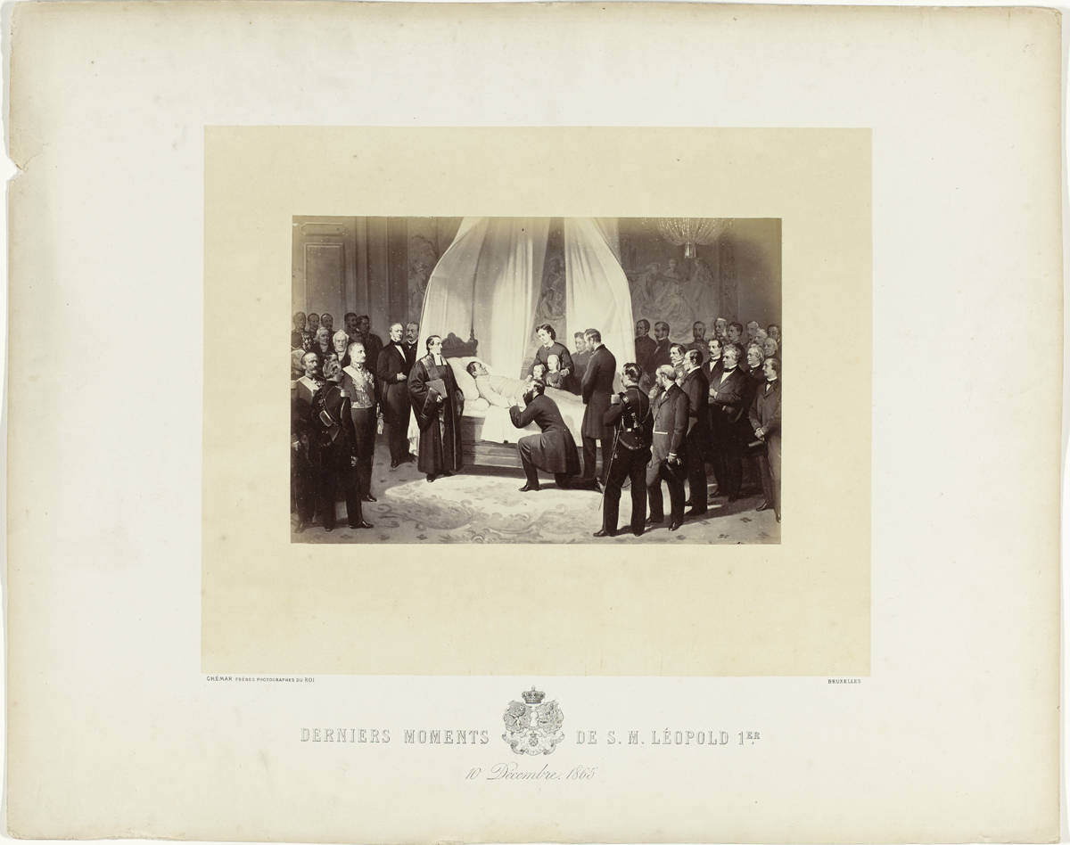 |
Fig. 4. Ghémar Frères, Derniers moments de S.M. Leopold Ier, 10 décembre 1865. Albumen print, 17 x 25 cm. Plate from Ghémar Frères, Funérailles de S.M. Léopold Ier. Roi des Belges et avénement de Léopold II au trone, Brussels 1866. Amsterdam, Rijkmuseum, inv. RP-F-2001-7-1654-4. |
Senne: Scale of 1 to 2066
The plan by Suys was accepted, and to make sure the City would not lose its money in the complex, risky game of real estate and expropriation, Anspach decided to make a deal with British investors. The Belgian Public Works Company Limited would be fully responsible for the execution of the works that eventually would start in February 1867.[44] In the ‘Contrat Provisoire’, there is not a single reference to the possible condition that the neighbourhood should be photographed. Also in the final Cahier des charges, also published in the Bulletin Communal, and signed the 2nd of August 1866, every stone seems to be described right down to the centimetre, but no direct reference can be found to the work of Ghémar.
Nevertheless, it would be this Company that seems to have commissioned Ghémar to make photographs of the banks of the Senne. The descriptive title (in translation: ‘Redevelopment of the Senne. Brussels in 1867. Photographic views taken at the location of the new boulevard that will be constructed throughout the City of Brussels, by Ghémar Frères. For the Belgian Public Works Company’) was printed on the front page of the album measuring 44 x 62 cm, containing 11 albumen prints of about 27 x 35 cm fixed on white cardboard.[45] Except for the dry stamp ‘Ghémar frères – Photographes du Roi – Bruxelles’, no comments, titles or specifications seem to have been added originally, although some of the photographs in the album have indications on the point of view, exactly like Marville’s photographs. Also like the photographs Marville made, there seems to be no specific order. Ghémar’s images are not bound together or numbered. Another remarkable aspect is the parallel in perspective: in Marville’s photographs, the view is directed into the empty street, Ghémar points to the empty, mirroring canal (figs. 5, 6). Only occasionally can persons be seen, such as on the photograph ‘Le Moulin du Borgval’ where a girl is leaning out of the window at the back. The other exception is the entrance to the Butter Market, where a few men are curiously looking at the camera. Ghémar was not asked to capture bad housing conditions, nor was he asked to document daily life. He made ‘views’ of the places where the new boulevard was supposed to come, and since he was a good commercial photographer, his images were beautiful.[46]
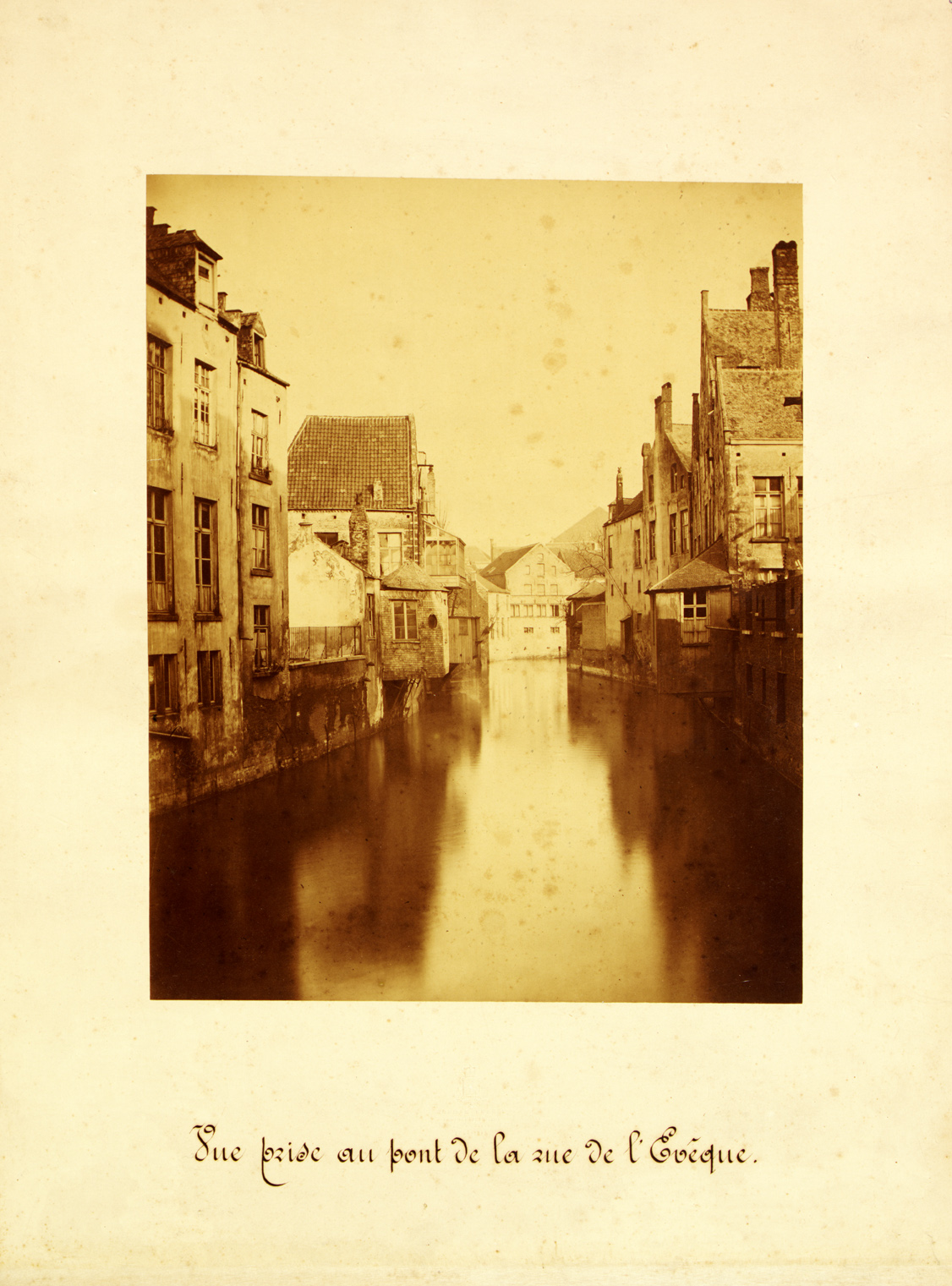 |
Fig. 5. Ghémar Frères, Vue prise au pont de la rue de l’Evèque. Albumen print, 27 x 35 cm. Assainissement de la Senne. Bruxelles en 1867. Vues photographiques prises à l’emplacement du nouveau boulevard à ouvrir au travers de la Ville de Bruxelles, par Ghémar Frères. Pour la Belgian Public Works Company. Archives of the City of Brussels, Album XVII-18 |
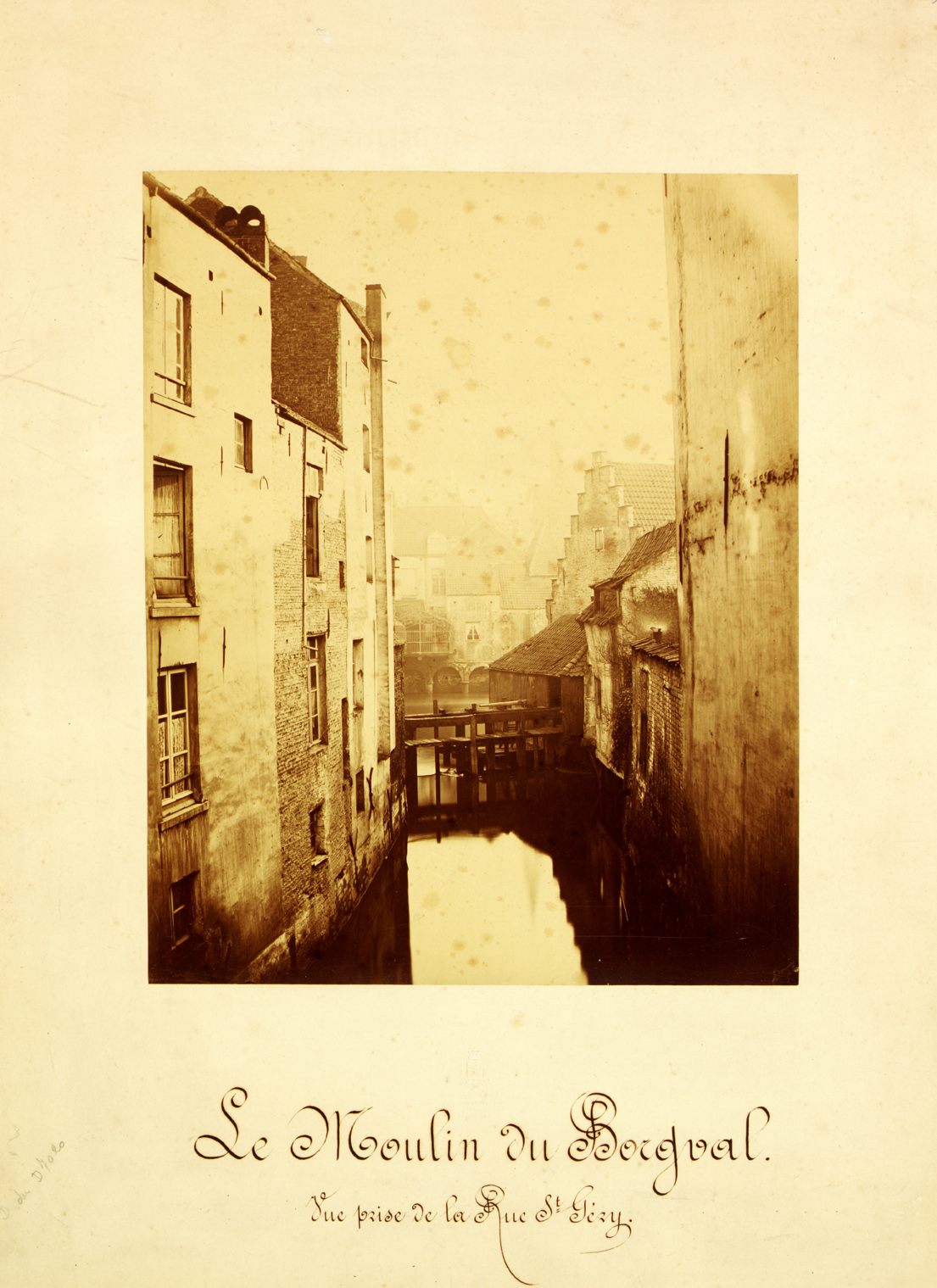 |
Fig. 6. Ghémar Frères, Vue prise au pont de la rue de l’Evèque. Albumen print, 27 x 35 cm. Assainissement de la Senne. Bruxelles en 1867. Vues photographiques prises à l’emplacement du nouveau boulevard à ouvrir au travers de la Ville de Bruxelles, par Ghémar Frères. Pour la Belgian Public Works Company. Archives of the City of Brussels, Album XVII-18 |
Although, as we will see, the influence of the Parisian administration in the Conseil Communal of Brussels was large enough to have the idea of hiring a photographer before destroying the poor quarters be copied as well, another publication might provide an explanation for the purpose of the commission. In the Archives de la Ville de Bruxelles, the album Belgian Public Works Company Limited. Assainissement de la Senne. Tracé des Boulevards et Plan parcellaire de la Zone d’expropriation. Echelle de 1 à 2066 can be found. [47] The album consists of photographic reproductions of the original drawings.[48] Below the eight albumen prints of the maps on the eight pages, and on the front page, on the white cardboard, the name of the photographer is printed: ‘Ghémar frères, photographes du Roi, Bruxelles’. Why would the company use expensive and elaborate photographs for the reproduction of the maps, when lithography could be used much more easily? The answer lies in the first page. Barely visible on the top right corner, two different handwritings can be deciphered: this Tracé has been signed, and this signature had to be reproduced as faithfully as possible: in photography (fig. 7).
 |
Fig. 7. Ghémar Frères. Front page of Belgian Public Works Company Limited. Assainissement de la Senne. Tracé des Boulevards et Plan parcellaire de la Zone d’expropriation. Echelle de 1 à 2066. Albumen print, 24 x 13,5 cm. Archives of the City of Brussels, Album VII-8 |
This handwritten text declares that on the 19th of July 1867, one of the engineers of the Ville de Bruxelles, declared his agreement to the dates of expropriation ‘that can be read on the lithographic prints that can be seen in this atlas’, as well on ‘four corrections indicated in blue’. On the 28th of July 1867, the ‘secrétaire de la Ville’ signed the copies of the ‘plans d’assainissement’, as agreed between the different parties. Four of the eight maps indeed have remarks added in pen.
These maps were reproduced by photography to duplicate the signatures, to confirm the agreement the Company had made with the City. Photography was used in a way Ghémar was familiar with – as a means of reproduction – but also to provide proof. It is most likely that the Company got to know Ghémar from the publication of Suys, and then asked Ghémar to make duplicates of the final plans. Somewhere in this procedure, Ghémar must have been commissioned to make photographs of the ‘place where the new boulevard will be built’, as the title of the other album says. Perhaps he did so on his own initiative. However, if he seriously would have thought the ‘views’ would find buyers, it would have been more likely that he would also have them edited as an album like his other work. But he didn’t. The photographs were administrative documents, meant to circulate in the city archives. The album would prove to the city council that the British Company was seriously engaged in the project.[49] In that sense, the gesture might have been more important than the actual documents. The photographs followed aesthetic rules on composition and contrast, but most of all, as the photographs of the Parisian streets, they are documents that would belong in the archives: they show the course of the river before this part of the city would be changed forever.
Senne after Seine
Anspach was very keen on modelling his city after Paris and having Haussmann as his example: it got him the nickname ‘Ansmann’.[50] Anspach kept a correspondence with his Parisian counterpart, specifically on the transformation works, and he visited the Ville Lumière regularly.[51] As Abeels and others have suggested, the City of Brussels might indeed have simply copied the commission to Marville – as happened with basically all aspects of the urban transformation.[52]
Besides these connections on the highest level, there seems to have been more traffic between Brussels and Paris. Already in 1861 a commission was called together by the provincial government of Brabant to examine ten projects to sanitize the Senne area. In 1864, the Commission declared it had studied the sanitation works in the neighbouring capitals of London in Paris, the last one was taken as its example.[53] The Commission even had had personal contact with Eugène Belgrand,[54] the chief engineer of the Service des Eaux et Egouts de Paris – someone Marville probably knew as well – who had advised them on adapting the Parisian solutions to the situation in Brussels. In March 1866, another commission in which Anspach took part would visit the sewers personally.[55] At that time, Marville had already made his first photographs of the streets.
Seine: Fac-simile
‘The Service Historique de la Ville de Paris has hopefully understood that it should hire photographers to take care of the illustrations in l’Histoire Générale de Paris,’ Ernest Lacan remarks in his journal Moniteur de la Photographie in March 1867.[56] Almost one year later the Moniteur opened, very exceptionally, with an illustration. It is an image the ‘Collège du Cardinal Lemoine’, a detail of a map, a ‘Fac-simile héliographique’ of the ‘Plan de Mérian’ of 1643. It was one of the maps that had been published in Les anciennes bibliothèques de Paris in 1867. Like the Topographie Historique, the book was part of the Histoire Générale de Paris, the project launched in 1860 by Haussmann, resulting in its first publication in 1866.[57] In the introduction Haussmann personally explained the purpose: to constitute a collection of original documents, whose publication independent historians would never be able to finance.[58]
More than ten years late, in 1880,r the Ville de Paris published an Atlas des anciens plans de Paris. The title page promises ‘reproductions in facsimile of the originals, the rarest and most interesting for the history of Parisian topography’.[59] The atlas contains 31 maps, which are divided in two parts: the ‘Plans rétrospectifs’, i.e., maps of a time that no decent maps were made. These maps are drawn ‘approximatively, or more or less scientifically’. The most special one, according to the editors, is the ‘Plan archéologique de Paris, du XIIIe au XVIIe siècle’, drawn by Adolphe Berty. ‘Berty thought he could translate by crayon […] the written documents that are stored in the archives. First he looked for the trace of the street, then at the blocks …’[60] This is once more the big mapping project by Berty, where Marville has made his contribution in the detailed rendering of the walls of the medieval streets.
In addition, three of the ‘plans contemporains’ (which means that the map had been made by ‘eyewitnesses’) were reproduced: Planche VIII, X and XII, maps from the sixteenth century, have in the left corner below the inscription ‘Heliog.re P. Dujardin, Phot. Ch. Marville’. Marville made photographs of the originals, and afterwards Dujardin printed them as photogravures.
Although Marville is not mentioned in the first text of a report with the promising title Rapport sur la proposition tendant à reproduire par la photogravure les anciens plans de Paris et à les réunir dans un atlas qui figurera à l’Exposition Universelle de 1878 …, in the last pages he is.[61] Dated 29 December 1879 in the Annex, it says: ‘the material execution had to be carried out with a lot of care. It has been taken care of, regarding photography, by Mr. Marville, who has died without having seen the result of his work.’[62] It would be the only time Marville would be mentioned in a publication by the Ville de Paris. Like Ghémar, Marville was a photographer who could be hired to make reproductions of maps, a job that was at least as important as reproducing buildings that would be demolished.
Before and after
Both Charles Marville and Ghémar Frères were commercial entrepreneurs, who were lucky to have their city administration as a loyal customer. Marville’s street photographs should be seen in the first place as recordings of the medieval street patterns, intended as a neutral scientific addition to the existing medieval plans. When the Parisian city archives vanished in the fire at the Hôtel de Ville, the value of the photographs rose – and melancholy would follow shortly after. Although no direct connections could be found, with the focus of the Brussels administration on their southern neighbour it is likely that Ghémar was asked to make photographs of the ‘location of the new boulevards’ after Brussels’ civil servants had heard about Marville’s project. The parallel in the photographers’ part in the reproduction of valuable documents is remarkable – Marville ancient maps, Ghémar the building contract including the routes of the future boulevards.
Despite the desire of modern art historians to see the documenters of the vanished neighbourhoods as visionary independent artists, Charles Marville and Ghémar Frères were commercial entrepreneurs who were doing exactly what they were asked.
Thirty years after Marville had received his commission, Marcel Poëte became librarian at the Historical Library of the Ville de Paris. He was looking for new ways to write the history of the city: he started exhibiting the signs and publicity from the streets, and ordered prints be made of the glass negatives by Marville that had been stored in the archives. At the same time Eugène Atget started selling his series of his ‘Le Vieux Paris’ to Parisian institutions. Twenty years before the artist Man Ray would discover Atget’s photographs, Poëte would be one of his most faithful buyers. In the history of photography, this would transform Marville into a predecessor of Atget, both in search for a vanished city.[63] In Brussels, the new mayor, Charles Buls, regretted the disappearance of Old Brussels – he was one of the founders of the Comité d’Étude du Vieux Bruxelles. In 1893, in his acclaimed essay ‘L’Esthétique des Villles’, he proclaimed that cities should have organic structures. Although he agreed that sanitation of the Senne neighbourhood was more than necessary, he had ordered the painter Jean-Baptiste van Moer make paintings after the watercolours the artist made during the Sanitation of the Senne. The paintings, on which the sun enters much more often on the Senne than was the case on Ghémar’s photographs, would have a place of honour: in the office of the Mayor, in the Hôtel de Ville. The inhabitants along the Senne had moved twenty years before, but the visual transformation had only yet begun.
CV
Joke de Wolf (MA with honours) studied Art History at the University of Amsterdam, and History of Photography at Paris- Sorbonne and Lhivic (EHESS) in Paris. She was Scaliger Fellow at Leiden University, doctorate fellow at the Graduiertenkolleg Mediale Historiographien at the universities of Erfurt, Jena and Weimar, and Wissenschaftliche Mitarbeiterin (Assistant Professor) at the chair of History and Theory of Photography at the University of Cologne. She is now working as an art journalist and she is preparing her PhD-thesis at the Rijksuniversiteit Groningen. The use and application in archives, world exhibitions and magazines of the photographs ‘Du Vieux Paris’ made by Charles Marville for the City of Paris is the subject of her thesis.↑
Notes
1. Louis Ghémar (Lannoy (France) 1819- Brussels 1873) was trained as a lithographer, in 1854 he started a photographic enterprise with Robert Severin in Antwerp. The company moved to Brussels in 1855. From 1860 the enterprise, with Severin as assistant, is called Ghémar Frères (Dewilde 1996, p. 4). Charles Bossu (1813-1879) was trained as lithographer; after 1834 he published and worked under the name of Charles Marville. (http://www.lemonde.fr, 11 December 2010) From 1851 until his death he worked as a commercial photographer in Paris. Among his clients were the publishing house of Blanquart-Evrard, the Musée (Impérial) du Louvre, architects such as Viollet-le-Duc, and the City of Paris.↑
2. On the problematic relationship between the nineteenth-century photographer, his commissioners and art-historiography, see Krauss 1982, p. 313 and [note 17]. On the role of street photography in (political) history, see Tagg 1993, pp. 117-52. On commercial photography in the nineteenth century, see McCauley 1994.↑
3. To mention only the most important: in Paris, Henri Le Secq and Richebourg, in Brussels Adolphe Braun and Jean Kämpfe.↑
4. The photographs Thomas Annan made for the Glasgow City Improvement Trust, published in 1877 as ‘Photographs of Old Closes, streets, &c, taken 1868-1877’, show very interesting similarities with the photographs from Marville and Ghémar. These similarities will be discussed in my dissertation.↑
5. This title was first mentioned in a letter of 13 November 1882, when, after Marville’s death, his successor Armand Guérinet sold the negatives to the City, together with Marville’s photographs of construction sites and new street furniture. ↑
6. The website of the City of Paris provides an excellent service in making all the photographs accessible online in very high definition: look for ‘Photographies des rues de Paris sous le Second Empire’ on bspe-p-pub.paris.fr.↑
7. Newhall 1964, p. 72.↑
8. The term mayor is misleading: the prefect de la Seine was directly accountable to the emperor (Napoléon III), it was only in 1968 that Paris would have a mayor.↑
9. Hambourg (1981), p. 10.↑
10. Since the dates for the demolition of many of the streets are known, the photographs can be dated quite precisely This has been done by the Bibliothèque Historique de la Ville de Paris.↑
11. Marie de Thézy is the former curator of photography at the Bibliothèque Historique de la Ville de Paris – the place where most of Marville’s glass negatives have been stored since 1881.↑
12. She also mentions the use of the photographs in the Histoire Générale de Paris, but without mentioning what the photographs were used for. For the contemporary reader, this suggests that the photographs would serve as illustration in recent city history (De Thézy 1994, p. 28). See for example Reynaud 2010, p. 163; Scott 2007, p. 90; Tambrun 1997, p. 197; De Thézy 1996, n.p.; Hambourg/De Thézy 1981, p. 10.↑
13. In the final version the month has been changed to January, however, the remarks on the draft version of the letter and the initial letter by Marville, written on the 30th of January, prove that this was an error in transcription.↑
14. Subject of the note: ‘Acquisition d’une collection de vues de Paris pour le service du plan et le service des travaux historiques’: ‘Avant de commencer les grands travaux de percement qui ont renouvelé l’aspect et la topographie du Vieux Paris, l’Administration avait cru qu’il était intéressant de conserver les souvenirs du passé, et dans cette pensée, elle avait commandé à M. Marville, photographe, une suite de 425 vues des anciennes voies détruites ou sur le point de l’être. Cette collection, dont M. Marville a conservé les clichés qui lui permettent d’en tirer de nouvelles épreuves, offre un grand intérêt par suite de l’anéantissement de tous les relevés déposés à l’ancien bureau du Plan. Elle serait aussi d’un grand secours pour la préparation des volumes de la topographie historique du Vieux Paris, dont s’occupe le service des Beaux-Arts et des Travaux historiques.’ Letter in Dossier Marville, Musée Carnavalet, Paris.↑
15. Service des Travaux de Paris was the name for the general Public Works department. Adolphe Alphand, former chief of ‘Promenades et Plantations’ was its director in 1873. He was chief over the Service du Plan, Service des Beaux Arts and Service des Travaux Historiques.↑
16. Michaux approves the acquisition, but remarks it should be paid for by the Service du Plan. ‘J’approuve la proposition faite par mon collègue pour l’acquisition de la Collection Marville. La dépense, évalué à 1400 franc, pourrait être imputée sur le fonds disponible du Service du plan (Ch. 12, dépenses imprévues en 1872). Le chef des B.A.’ Letter in Dossier Marville, Archives du Musée Carnavalet, Paris.↑
17. ‘Je prends la liberté de rappeler à votre souvenir que j’ai conservé tous les clichés qui ont été exécutés par moi pour l’Administration Municipale, ainsi que j’avais l’honneur de vous le signaler vers la fin de 1871. Une grande partie des épreuves émanant de ces clichés ont été détruites dans l’incendie de la Ville, entr’autres une collection de 425 vues des voies détruites où à détruire pour les percements projetés & exécutés. De cette suite il n’avais été qu’un seul exemplaire. Il n’en n’est donc plus de trace. Je n’ai pas besoin de vous faire remarquer, Monsieur, de quel interêt est cette suite pour la topographie de Paris. En rappelant ce qui précède à Votre Mention, je viens solliciter de vous, Monsieur le Directeur, la décision que vous m’avez dit devoir prendre lorsque le moment serait devenu opportun.’↑
18. A statement that the civil servant repeats, only changing the words to be more convincing to his superior officer.↑
19. De Thézy 1994, p. 32.↑
20. On 22 February a letter was sent to Marville that his commission was accepted. These could be the prints that are now kept in the Bibliothèque de l’Hôtel de Ville: a series that were registered in the library in 1875, when the catalogue was started. They are called ‘vues des rues’: large albumen prints, on cardboard support, with a description of the point of view of the photograph. ‘24 mars 1875. Vues des rues, places, marchés et subsidiairement des monuments de Paris, reproduits par la photographie. Environ 300 pièces, en feuilles, renfermées dans 4 portefeuilles et un paquet-in-folio. Origine: envoi de M. le Préfet, pas de prix, don.’ Catalogue of the Bibliothèque de l’Hôtel de Ville, Paris, nr. 1107.↑
21. Although the complete transformation according to the plans of Haussmann would not have completed until the 1920s, most of the streets Marville photographed were would have vanished before Haussmann would leave office in 1870.↑
22. Le Gall 2007, p. 19.↑
23. Adolphe Berty (1818-1867). Architect, listed as ‘historiographe’ at the Service des Travaux Historiques in 1866 (Recueil des actes administratifs de la Préfecture du département de la Seine (1866), Tome 1, p. xiii). After his death the series of Topographie Historique was continued to a total of 8 editions.↑
24. Berty 1866, p. xii.↑
25. Berty 1866, p. xiii: ‘Les murs mitoyens latéraux n’étaient autrefois presque jamais déplacés’.↑
26. Berty 1866, p. xv: ‘Nous ne prétendons certes pas à l’infaillibilité; mais ce que nous pouvons dire, c’est que nos restitutions, dont l’exactitude a été si souvent confirmée, sont établies avec une probabilité tout à fait scientifique.’↑
27. See, for example Lacan 1868, p. 170: ‘Devant la justice, [la photographie] a permis d’établir des constats irréfutables en présence de l’histoire, elle se pose comme le seul témoin qu’on ne puisse récuser’.↑
28. Berty 1866, p. xviii: ‘L’anecdote a été bannie de cet ouvrage; ce serait, du reste, un souhait stérile que celui d’une histoire ancedotique et récréative des habitations du Vieux Paris, il n’y a presque rien à recueillir sur cette matière.’ Louis XIII lived from 1601 until 1643.↑
29. Berty 1866, p. xx: ‘Rien n’est moins facile quand on veut opérer avec précision’.↑
30. Berty 1866, p. xx: ‘L’année de la mort de Henri IV est […] le terme naturel auquel il convient de s’arrêter, car moins d’un demi-siècle après commence, par le plan de Gamboust, la série des travaux graphiques dignes de confiance.’↑
31. All volumes of the Topographie Historique can be consulted online, at http://gallica.fr. ↑
32. Photographs by Marville only appear to have been reproduced in the fifth edition. Berty 1887, pp. 318, 319, 486, 524, 556, 557, 558 and 566.↑
33. Abeels 1977, p. 85: ‘Assez paradoxalement, cette photographie documentaire est loin d’être impersonelle. Il ne s’agit pas d’enregistrer mécaniquement n’importe quel site qui se présente devant l’objectif: il faut choisir avec précision l’heure et le jour le plus propices à telle ou telle prise de vue.’↑
34. Abeels 1977, p. 85: ‘… cette société confie à Louis Ghémar la mission de photographier, le long de la vieille Senne, les coins pittoresques condamnés à disparaître.’ On Ghémar Frères, see: Dewilde 1996; Coppens/Roosens/Van Deuren 1989, pp. 106-110, 124, 138-141; Abeels 1977, pp. 53-97.↑
35. Leenaerts 2010, p. 27. In 2012, however, Leenaerts takes the photographer-artist perspective and suggests that Ghémar had the ‘desire to preserve a memory of old Brussels which was above all poetic’. Leenaerts 2012, p. 4.↑
36. Léon Suys (Amsterdam 1823-Ixelles 1887). Besides the covering of the Senne, Suys also designed the Bourse (1871-73) and Les Halles Centrales. See Abeels 1983, p. 155.↑
37. See Wagenaar 1998 and Abeels 1983.↑
38. Röttger 2006, p. 31.↑
39. Bulletin Communal de Bruxelles, 1865, II, p. 292: ‘Cette combinaison nous a paru extrêmement heureuse, parce qu’elle ouvre une voie importante et nouvelle, destinée à mettre en communication les deux stations, qu’elle dégage le trop plein de la circulation de la rue Neuve, de la rue des Fripiers et de la rue du Midi, et surtout parce qu’elle coupe et fait disparaître la plupart des ruelles étroites qui ont leur origine à la rivière et qui sont la partie la plus malsaine comme la plus triste de l’agglomération bruxelloise, et enfin qu’elle fait entrer l’air et la lumière, la vie et la circulation dans un quartier qui tend à s’appauvrir.’ Assainissement de la Senne et travaux pour préserver la ville des inondations, d’après le projet de MM. les ingénieurs en chef, constitués en commission par arrêté ministériel du 3 juin 1864; création d’un boulevard central, de rues et de places, construction d’’une Bourse de commerce, de halles centrales et d’une fontaine commémorative, d’après le projet de M. l’architecte Suys. Rapport présenté au Conseil communal, au nom du Collège, par M. le Bourgmestre, en séance du 2 octobre 1865.↑
40. Suys 1865, p. 20: ‘Comme Paris, Bruxelles se transformera en s’enrichissant.’.↑
41. Ghémar Frères 1866. ↑
42. ‘Photographes du Roi’. ↑
43. Léon-Pierre Suys, Arc de triomphe de Léopold Premier et temple de la renommée. Projet de monument national. Charles Lelong, Brussels 1866, mentioned in Fincoeur/Silvestre 2000, p. 390. ↑
44. Fincoeur/Silvestre 2000, pp. 305-06.↑
45. The album in the Archives de la Ville de Bruxelles (Album XVII-18) contains one photograph more than the album in the Royal Library of Brussels, but since this image of the South Station (Abeels 1982, p. 158) is both the only horizontally oriented image, as the only image that shows new construction, it is likely that it was added later.↑
46. Knowing the photographs of Ghémar, it might be remarkable to read how negative the Conseil Communal is on the river Senne – not once is the destruction of the old neighbourhood around it contested. In a discussion about the watering of the trees, in November 1866, M. De Roubaix states that ‘the water of the canal is some of the worst available in Brussels today. To be convinced, you only need to walk on the Allée-Verte in summer. The smells that one perceives there and that come from the canal take away all illusions on clean water’ (L’eau du canal est aujourd’hui l’une des plus mauvaises qu’il y ait à Bruxelles. Pour s’en convaincre, il suffit de se promener à l’Allée-Verte, en été. Les odeurs qu’on y respire et qui émanent du canal ôtent toute illusion sur la pureté de ses eaux’). Conseil Communal of 10 November 1866, Bulletin Communal de Bruxelles, 1866, Tôme II, p. 414.↑
47. Archives de la Ville de Bruxelles, Album VII-8.↑
48. Unfortunately, the original documents could not been found.↑
49. An engagement Anspach had to defend in front of his Conseil from the beginning of the project until the company would be declared bankrupt, in 1871 (Abeels 1983, p. 111). ↑
50. In the popular cabaret in Brussels in the 1870s (Leblicq 1979, p. 42). ↑
51. In one of the rare letters that have survived, dated 1 February 1867, which was read out loud in the Chambre des Représentants by Anspach when he had to defend unnecessary embellishments, Haussmann answers the questions Anspach had asked him about the costs of the ‘opérations de voirie’ (Garsou 1942, p. 132). Unfortunately, this seems to be the only letter that has been preserved. Anspach’s biographer writes in 1942 that the drawer of the mayors desk at the Hotel de Ville was emptied out by the mayor personally shortly before his death, and only contained a few letters of no importance. His personal papers, as well as his ‘papiers politiques’, had been destroyed by Anspach himself (Garsou 1942, p.133). In the discussions in the Conseil Communal, as printed in the Bulletin Communal, Paris is mentioned very regularly. Cf. Bulletin Communal 1866, I, p. 475; 1867, I, p. 35; 1867, II, p. 309.↑
52. Leblicq 1979, p. 283; Abeels 1977, p. 89.↑
53. ‘Rapport de la Commission des ingénieurs en chef, instituée par M. le Ministre des travaux publics, pour l’étude des questions relatives à l’assainissement de la Senne’, Bulletin Communal de Bruxelles 1865, I, p. 155.↑
54. Bulletin Communal de Bruxelles, 1865, I, p. 169: ‘M. Belgrand […] a eu la bonté de nous donner tous les renseignements désirables et d’y ajouter des avis précieux dictés par l’expérience.’↑
55. Abeels 1983, p. 101.↑
56. Lacan 1867, p. 1: ‘Pendant que ces méthodes, qui sont en quelque sorte la transition entre la photographie proprement dite et la gravure, se perfectionnent, l’étude des moyens de transformer l’image photographique en planche gravée, se poursuit avec une activité toujours plus grande. MM. Nègre, Baldus, Garnier, Placet, Durand et Lemaire ont si bien réussi que dès maintenant, la gravure héliographique a pris sa place parmi les procédés . illustration employés pour les ouvrages qui exigent à la fois la précision et le mérite artistique.’↑
57. To be continued until 1987, comprising 76 volumes.↑
58. These words of Haussmann are published in the form of a report to the emperor, ‘exactly’ confirming, in itself, the announced method of reproducing authentic historical documents.↑
59. Atlas 1880.↑
60. Atlas 1880, Table analytique des plans reproduits. ↑
61. ‘… présenté par M. Engelhard au nom de la troisième Commission’ (Annexe au procès-verbal de la séance du 23 février 1878). ↑
62. Rapport du Conseil Municipal de Paris, sur ‘Le supplément de crédit nécessaire pour acquitter les frais de l’édition de l’atlas des anciens plans de Paris, présenté par M. Engelhard au nom de la Troisième commission (annexe au Procès Verbal de la Séance du 29 décembre 1879), printed in the Atlas (1880), p. 14: ‘L’exécution matérielle devait répondre à tant de soins. Elle a été confiée, pour la photographie, à M. Marville, qui est mort sans avoir vu l’achèvement de son oeuvre, et, pour la gravure, à M. Dujardin, dont les procédés héliographiques ont atteint un haut degré de perfection.’↑
63. Calabi 1996, p. 425. ↑
Literature reference
http://www.lemonde.fr/culture/article/2010/12/11/un-scoop-du-xixe-siecle-le-photographe-marville-s-appelait-bossu_1452246_3246.html, accessed 14 December 2010
Atlas des anciens plans de Paris: reproduction en fac-similé des originaux les plus rares et les plus intéressants pour l’histoire de la topographie parisienne avec une table analytique présentant la légende explicative de chaque plan et un appendice consacré aux documents annexes, Paris 1880.
Bulletin Communal de Bruxelles 1866-67.
Recueil des actes administratifs de la Préfecture du département de la Seine, 1866, Tome I.
Abeels, Gustave, Les Pionniers de la Photographie à Bruxelles, Zaltbommel 1977.
Abeels, Gustave (ed.), Straten en stenen. Brussel: stadsgroei 1780-1980, Brusselsc 1982.
Abeels, Gustave, La Senne, Brussels 1983.
Berty, Adolphe, Topographie Historique du Vieux Paris. Histoire Générale de Paris, Paris 1866.
Calabi, Donatella, ‘Marcel Poëte: Pioneer of ‘l’urbanisme’ and defender of ‘l’histoire des villes’’, Planning Perspectives Vol. 11 No. 4, pp. 413-36.
Coppens, Jan, Laurent Roosens, and Karel Van Deuren, ‘…door de enkele werking van het licht …’. Introductie en integratie van de fotografie in België en Nederland, 1839-1869, Brussels 1989.
De Thézy, Marie, Paris Marville, Paris 1994.
De Thézy, Marie, Charles Marville, Paris 1996.
Dewilde, Jan, De Salon van Louis Ghémar. Een fotoreportage van de Algemene Tentoonstelling van Schone Kunsten te Brussel in 1863, Ieper 1996.
Fincoeur, Michel-Benoit, and Marguerite Silvestre, Inventaire raisonné des collections cartographiques Vandermaelen, conservées à la Biliothèque Royale de Belgique, IV. Brussels 2000.
Garsou, Jules, Jules Anspach, bourgmestre et transformateur de Bruxelles (1829-1879), Brussels 1942.
Ghémar Frères, Funérailles de S.M. Léopold Ier. Roi des Belges et avénement de Léopold II au trône, Brussels 1866.
Hambourg, Maria Morris, ‘Charles Marville’s old Paris’, in: Maria Morris Hambourg and Marie de Thézy, Charles Marville : Photographs of Paris at the time of the Second Empire on loan from the Musee Carnavalet. Paris, New York 1981, pp. 7-11.
Krauss, Rosalind, ‘Photography’s Discursive Spaces : Landscape/View’, Art Journal 42 (1982), pp 311-19.
Lacan, Ernest, ‘Revue photographique’, Le Moniteur de la Photographie, No.1, 7e Année, 15 Mars 1867, p. 1.
Lacan, Ernest, ‘Histoire Générale de Paris’, Le moniteur de la Photographie, No. 22, 7e année, 1 February 1868, pp.169-70.
Leblicq, Yvon, ‘Evolutie van het uitzicht van Brussel in de 19e eeuw’, in: André Monteyne, Brussel, breken, bouwen. Architectuur en stadsverfraaiing 1780-1914, Brussels 1979, pp. 11-92.
Leenaerts, Danielle, L’Image de la Ville. Bruxelles et ses photographes des années 1850 à nos jours, Brussels 2009, pp. 27-29.
Leenaerts, Danielle, ‘Photographic representations of Brussels at the turn of the 19th and 20th centuries: from documentation to artistic expression’, Brussels Studies No. 57, 5 March 2012, www.brusselsstudies.be.
Le Gall, Guillaume, ‘Apparition du Vieux Paris’, in: Sylvie Aubenas and Guillaume Le Gall, Atget, une rétrospective, Paris 2007, pp. 13-25.
McCauley, Elisabeth Anne, Industrial Madness : Commercial photography in Paris. 1848-1871. New Haven/London 1994.
Newhall, Beaumont, The History of Photography : From 1839 to the present day. Revised and enlarged edition. London 1964.
Reynaud, Françoise, ‘Eine Reise durch die fotografischen Sammlungen von Paris’, in: Bilder einer Metropole. Die Impressionisten in Paris, Göttingen 2010, pp. 157-69.
Röttger, Rik, ‘Capitol and Capital. Het ‘moment Anspach’ in de Brusselse urbanisatie en liberale politieke cultuur (1860-1880)’, Stadsgeschiedenis No. 1, 1e jaargang, 2006, pp. 27-50.
Scott, Clive. Street photography : From Atget to Cartier-Bresson, London/New York 2007.
Suys, Léon. Bruxelles, Senne et Boulevards. Solution du problème hygiénique et monumental, Brussels 1865.
Tambrun, Catherine, ‘Photographie et urbanisme à Paris à travers trois fonds de photographies conservés au Musée Carnavalet’, Espaces et sociétés 90/91 (1997), pp. 195-214.
Tagg, John. The Burden of Representation : Essays on Photographies and Histories, Minneapolis 1993, pp. 117-52.
Wagenaar, Michiel. Stedebouw en burgerlijke vrijheid. De constrasterende carrières van zes Europese hoofdsteden, Bussum 1998, pp. 24-69.